Powered By Blogger
Showing posts with label southindianweatherman. Show all posts

Friday, June 10, 2016

Monsoon Has finally arrived.. Happy Monsoon 2016.


The southwest monsoon has reached Kerala and as a result marked the onset of the monsoon over the Indian sub continent and the start of Monsoon season 2016. 

Heavy to very heavy rainfall has been reported at most places over Kerala and coastal Karnataka over the last 2 days.

As of today the monsoon has covered the whole of Kerala, coastal Karnataka and Tamil Nadu, most of south interior Karnataka and Rayalseema - The Northern Limit of Monsoon (NLM) passes through Lat. 14.0°N/ Long.60.0°E, Lat. 14.0°N/ Long.70.0°E, Honavar, Anantapur, Ongole, Lat.16.0°N/ Long. 85.0°E, Lat. 17.0°N/ Long.90.0°E and Lat. 18.0°N/ Long.94.0°E.


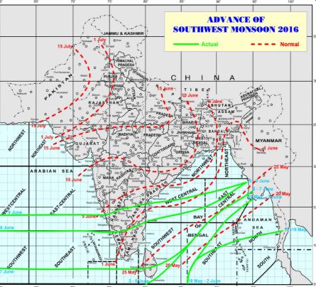
The monsoon is making its way up the west coast quickly and should cover entire Goa and parts of coastal Maharashtra in the next 48 hours. On the east coast the monsoon has made its way up to Myanmar and parts of north-east India, The Northeastern states will start receiving heavy rain from today onward.


Monsoon is expected to make its way up quickly helped by twin systems / upper air cyclonic circulations in the bay of Bengal and Arabian sea although cross equatorial moisture has decreased.


Monsoon winds will keep moving north although it will take between 48-72 hours for it to strengthen again and provide heavy rainfall over the country.


We expect the monsoon to cover most of the country and reach Kolkata by the 11th of June and Mumbai by the 13th of June and Delhi by the 29th/30th of June.


For regular updates follow me on Facebook - 

Southindiaweatherman Facebook page


Next Update 27th June - Monsoon onset & 1st phase performance of monsoon report..

Wednesday, May 4, 2016

Pre monsoon showers have begun..


Pre-monsoon showers have begun throughout the country including South Interior Karnataka.


Current satellite image showing thunderstorms over south and east India. coming weeks will see an increase in rainfall activity across the country - IMD / South Indian weatherman.


Outlook for the rest of the month looks very promising, heavy thundershowers expected along west coast and interior Tamil nadu and Karnataka reaching up to Telangana, Madhya Maharashtra and Madhya pradesh, to the east, West Bengal and the rest of NE states will receive heavy rainfall with possibility of squalls in the region.


The only region which will miss out is the east coast of the country from southern Tamil nadu through to Orissa.


Tamil nadu will also see the start of peak summer or 'Khattri' and temperatures are expected to reach into the mid 40's by mid May.


Heat wave regions of the last month should see temperatures fall by 2-3 degrees over the next week or so.


Next report (Monsoon onset report) in 3rd week of May.


Monday, April 18, 2016

Much needed April showers to begin shortly


The Much needed, eagerly awaited and long overdue April showers for 2016 over Bangalore and the rest of South Interior Karnataka will begin shortly.


With maximum temperatures hovering between 37 - 38 degrees over the city and minimums around 25 degrees there has been no respite from the sweltering heat even in the nights. 


These Vagaries when compared to last year when the city received over 200mm rainfall for the month of April alone make the heat feel much much worse.


However, some hope is around the corner, with a slight change in wind direction and the formation of a trough near the comorin area the coming days from the 19th onwards will see increase in clouds towards evening  / night. Wind speeds will also increase slightly during the evenings.


Isolated to scattered light thundershowers can be expected around South interior Karnataka from 19th April evening onwards.


An increase in thunderstorm activity is expected around the 21st - 23rd after which the thunderstorm activity will decrease again for a week or so to pick up again at the end of the month and beginning of May.


Total rainfall expected for April is around 80mm, slight reduction in minimum temperatures from 20th onwards.


Next update in first week of May

Tuesday, June 23, 2015

Forecasted to be weak and below normal, Monsoon throws up surprises.


South West Monsoon 2015 has till today the 23rd of June 2015 covered more than half the country with the northern limit lying on From West to East - Veraval, Surat, Ratlam, Bhopal, Ambikapur,

Bhagalpur and Supaul, still 5 - 6 days later than normal, although with twin systems in the Bay of 
Bengal and Arabian sea is expected to reach Punjab by the 28th or 29th of June about 3 days earlier 
than normal which will be a big relief for farmers and administration up north. 


The big news though is that the monsoon is currently in excess of 15% for the month and season so far which has caught many by surprise after the outlook by the IMD which was taking into account the effects of an el nino.


The main reasons contributing to the excess and active phase of the monsoon is a mildly strong MJO 

or Madden-Julian Oscillation - An equatorial Indian ocean system of currents that oscillates east to west and at different levels of intensity. The current MJO phase could last till the 26th or 27th of the month.


One more factor for the strong monsoon is a neutral IOD or Indian ocean dipole - again an anomaly in the sea surface temperatures in the Indian ocean which normally tends to counteract the El Nino. The IOD for week beginning the 22nd June showed it moving into a positive phase which should be good for the monsoon for the next week or so as well.


To Summarize, Monsoon should cover most of the country by the end of June with twin systems in 

the bay and Arabian sea, temperatures still very high in Rajasthan and Pakistan with the worst heat 
wave in decades, And a favorable MJO and IOD and a weak el Nino currently.


The next 9-10 days would continue to bring heavy to very heavy rainfall along west coast and 

central India, South India will see a decline in rainfall from today.


Forecast for coming weeks and rest of the monsoon.


Decline in rainfall over south India for next 2 weeks.Increase in rainfall over central and North India.


Strengthening of El Nino and weakening(neutral phase) of MJO and IOD around Second week of July.


July could see below normal rainfall over most of India except for a few places in West coast and North India.