Powered By Blogger

Friday, May 27, 2016

South-West Monsoon Update 2016


The South-West Monsoon winds after reaching Andaman on 18th is currently stalled a little north and west of the Andaman islands at Lat.5.0°N / Long.86.0°E, Lat.8.0°N / Long.87.0°E,  Lat.13.0°N / Long.91.0°E and Lat.16.0°N / Long.95.0°E.


https://1.bp.blogspot.com/-QPpwMU6cSK4/V0iqImlJGBI/AAAAAAAAAEI/ZJxrooNc4L0ygMTT2x0OR_Umbx6Sg9wUwCKgB/s640/monsoon%2Badavance.JPG


This current stall in the winds are because of the Cyclone 'ROANU' which pulled monsoon moisture and disrupted winds over the Bay of Bengal.

With 'ROANU' gone and winds over the bay gaining strength the monsoon has picked up speed and intensity and is making its way up to the coast of Kerala.

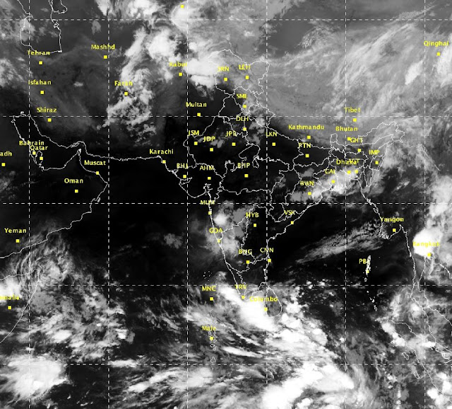
The conditions required for monsoon onset declaration are being met with regular pre monsoon showers and rainfall reported around Kerala and the westerlies in the 925hPa upto 600hPa over the latitudes 5-10 degrees N Latitudes between 10 - 20 knots. This accompanied with strong cross equatorial moisture flow will ensure strengthening of the monsoon says South Indian weatherman.


https://2.bp.blogspot.com/-PIsXv4-sook/V0iqJIuzAOI/AAAAAAAAAEU/BrRxOEVgtaU2GTc2XwZnRTewF-myJmtOwCKgB/s640/sat27.JPG


With temperatures over North-West and Central India expected to rise over the next 2-3 days the monsoon winds should move quickly and cover South India on time.


https://1.bp.blogspot.com/-bL6SgM44O8k/V0irzsBuKrI/AAAAAAAAAEo/_4r7nKd9fL0tVpuGM_LIfKB8iRXEJCcSwCLcB/s640/temp27.JPG


South Indian weatherman says Monsoon is expected to reach Kerala and monsoon declaration expected by the 08th - 09th of June which is over a week late and should cover most of south India up to parts of Maharashtra by the 15th, before a brief lull again will stall the winds for a week or so before moving into the rest of the country.


https://4.bp.blogspot.com/-S0zAqjUsnf0/V0iqIqiE5ZI/AAAAAAAAAEM/-qe0bPSCF9ERmu8Wplwfy_mC8zlLvZ1EACKgB/s640/16053100_2712.gif


https://1.bp.blogspot.com/-P4JVbBboNPI/V0irAmCWVTI/AAAAAAAAAEc/8ZGi3-YaCvgDuivefnzEanbN4bieIomyQCLcB/s640/16061212_2712.gif


Pre Monsoon showers will peak over South India between the 28th and until monsoon sets in. Heavy thundershowers & rainfall expected over Bangalore & rest of interior Karnataka & Tamil Nadu from the 28th.


https://1.bp.blogspot.com/-WKu3Xa2rXiI/V0iqItVoyBI/AAAAAAAAAEY/Ex9RNijgP2Y600igN2B52rDQkLw7nB3NwCKgB/s640/forecast123.JPG


Next Update from Southindianweatherman on 10th June 2016.....


Tuesday, May 10, 2016

First Depression of the year coming up in Mid May....


The area of convection previously located in the South East Arabian sea has moved eastwards and formed into a Low pressure area today the 14th of May 2016 near the southwest coast of Sri Lanka.


The area would move north-north eastwards over the next two days or so and strengthen into a depression /  deep depression by the 16th.


 It would move northwards skirting the east cost of India. Rainfall expected across most of south India from the 16th onwards.


The system after dumping heavy rainfall across the southern peninsula and weakening into a Low pressure would emerge again into the Bay of Bengal and strengthen again into a deep depression or Cyclone by the 19th.


It would then move North eastwards before crashing into West Bengal and Bangladesh by the 21st. Expect Pre-monsoon showers to peak over most of the country by the 23rd - 24th of May.


This system will help pull in monsoon moisture & winds from the bay and the monsoon will cover the Andaman and Nicobar islands between 17th - 19th May, Onset over Kerala is expected around the 30th of May 2016.


Heavy to very Heavy rainfall expected along the west coast of India - Kerala & Coastal Karnataka between 15th - 18th May. Also Heavy rainfall expected along east coast as well from Nagapattinam to Machlipatnam between the same dates.


Interior Tamil Nadu and Karnataka will also have moderate to heavy rainfall from the 15th onwards.


Next update - Monsoon onset update 28th May.


Wednesday, May 4, 2016

Pre monsoon showers have begun..


Pre-monsoon showers have begun throughout the country including South Interior Karnataka.


Current satellite image showing thunderstorms over south and east India. coming weeks will see an increase in rainfall activity across the country - IMD / South Indian weatherman.


Outlook for the rest of the month looks very promising, heavy thundershowers expected along west coast and interior Tamil nadu and Karnataka reaching up to Telangana, Madhya Maharashtra and Madhya pradesh, to the east, West Bengal and the rest of NE states will receive heavy rainfall with possibility of squalls in the region.


The only region which will miss out is the east coast of the country from southern Tamil nadu through to Orissa.


Tamil nadu will also see the start of peak summer or 'Khattri' and temperatures are expected to reach into the mid 40's by mid May.


Heat wave regions of the last month should see temperatures fall by 2-3 degrees over the next week or so.


Next report (Monsoon onset report) in 3rd week of May.